About

This site offers helpful information for visitors interested in enjoying the eclipse from federal public lands along and near the path of totality in western Oregon. Check back often for updates!


Tuesday, August 15, 2017

Multiple Fires Close Roads, Trails, Campgrounds, Portions of Mt. Jefferson Wilderness and Three Sisters Wilderness

Pacific Northwest Team 2, a Type I Incident Management Team, is responding to and monitoring multiple fires within the Willamette National Forest including:

French Fire: The fire is located approximately 1 mile northwest of Detroit, Oregon in an inaccessible drainage. Fire personnel will begin clearing nearby roads of debris with heavy equipment and continue line preparation to support direct and indirect firefighting tactics.

Whitewater Fire: The fire is actively burning near Whitewater Trailhead in the Mount Jefferson Wilderness and adjacent forest lands, approximately 13 miles east of Detroit, Oregon. Crews continue to improve and hold existing containment lines and advance construction of indirect lines along the western and northern edges. A newly discovered fire north of the Whitewater Fire received bucket drops of water yesterday and will continue to be monitored today.

Rebel Fire: This fire is burning in timber along the south fork of the McKenzie River and spreading into the Three Sisters Wilderness in an area of steep, rugged terrain. Today crews continue improving containment line along FS Road 19, the Aufderheide Scenic Byway. Brushing and chipping will further reduce the availability of burnable fuels along the road and the north end of the fire, from Cougar Crossing campground south to Forest Road 425.

Avenue Fire: Avenue Creek Fire is located two miles south of McKenzie River Ranger District office in inaccessible terrain. Crews continue to assess options for containing this fire using indirect tactics.

Box Canyon Fire: This fire is located approximately 6 miles south of the Rebel Fire. Crews completed line construction around the fire and extinguished all hot spots near the containment lines. This fire is in patrol status and will continue to be monitored by air.  Current resources will be shifted to higher priority fires in the area.

Weather and Fire Behavior: Warmer, drier weather is expected today with highs in the mid-70s, including northwesterly winds with gusts up to 15 miles per hour in the afternoon. Continued backing and creeping of flames with isolated torching is expected.

Fire Closures: Area closures are in place with numerous trails, campgrounds, and roads closed. Many campgrounds and trails in the eclipse path of totality are closed due to fires. This includes access to Mount Jefferson and Jefferson Park. For current conditions and closure information please visit https://www.fs.usda.gov/detail/willamette/fire/?cid=FSEPRD552029.

Online Links


Monday, August 7, 2017

All Trails into Mount Jefferson and Jefferson Park Will Remain Closed Through Aug. 21 Total Solar Eclipse Due to a Fire

The Willamette National Forest Service has announced that due to a combination of extreme fire conditions, explosive fire behavior and heavy smoke from a fire in the Mount Jefferson Wilderness, all access to Mount Jefferson and Jefferson Park is closed and will remain closed through the August 21 total solar eclipse.

“We understand this is a disappointment to residents and visitors who looked forward to the opportunity to experience the eclipse in this area. Unfortunately, the risk is too great, and our highest responsibility must be visitor safety,” said Forest Supervisor Tracy Beck. “Fueled by the excessively hot conditions of the previous weeks, this fire has burned very erratically and some nights has moved more than a mile through thick forests.”

The Willamette National Forest eclipse information page contains a series of maps that show adjacent National Forest lands that are currently open and lie in the path of totality of the eclipse. Visitors may want to consider these nearby sites to view the eclipse. For further information about the continued closure you can call the Eclipse Closure Information Line at 541-912-7548 or email eclipseteam2017@gmail.com
.
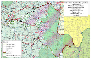
A map of the Whitewater Fire area closure in Mt. Jefferson WildernessThe size of the closure reflects the unpredictable fire behavior that fire managers have witnessed during the recent hot spell. To protect the public, all trails leading into the closed area will be staffed 24 hours a day to inform visitors and enforce the closure. Given the weather forecast and already dry forest conditions, the fire could continue to grow and additional closures could take place.

State officials predict thousands of travelers will visit Oregon to experience the eclipse on public lands. Expect crowds, traffic congestion, difficulty finding a campsite or parking spot, and limited supplies in smaller communities. It is recommended you bring a generous amount of water, food and emergency supplies.


For updates and more information, visit www.fs.usda.gov/willamette/ or  Twitter and Facebook @willamettenf

Monday, July 31, 2017

Planning on visiting Siuslaw National Forest for the eclipse? Here are some important updates

Our eclipse countdown clock is ticking away and we can’t believe there’s only one month to go before we’ll witness this spectacle in the sky. For those planning on visiting the Siuslaw National Forest to view the eclipse, here is some additional information to help finalize your plans.

In anticipation of the large numbers of visitors to the forest to view the August 21 total solar eclipse, forest officials are taking measures to ensure public safety and clear access for emergency vehicles, while protecting certain sensitive areas. As announced this spring, private vehicle access to Marys Peak and Mt. Hebo the day of the eclipse will be by reservation only (sorry – all reservations were booked by March 30), while access to Forest Service Road 1861 at Cascade Head will be first come, first served until maximum vehicle capacity is reached.  

Access to these three areas will be temporarily limited in the days leading up to the eclipse in order to effectively provide for public safety and resource protection. Eclipse and other visitors should be aware of the following (details and maps available online):

Marys Peak: Marys Peak Road above Conners Camp closed to private vehicles nights of Aug. 17 through  Aug. 20 (8pm – 6am). Marys Peak Road closed to private vehicles above Hwy. 34 8pm Aug. 20 to noon Aug. 21; eclipse permit holders and foot and bicycle traffic permitted beginning 6am Aug. 21. Woods Creek Road, which accesses the North Ridge Trailhead, will be closed to vehicles from 8pm Aug. 20 to noon Aug. 21; eclipse permit holder and foot and bicycle traffic permitted beginning 6am Aug. 21. The small Marys Peak Campground will be closed Aug. 17 through Aug. 21 to be used as a staging area for emergency services, staff, and volunteers supporting the event. As always, camping and campfires are prohibited on Marys Peak.

Mt. Hebo: Mt. Hebo Road (FS 14) closed to vehicles between Pioneer Indian Trailhead (milepost 5.3) and intersection with FS 1428 (milepost 11.4 just north of South Lake) starting 5pm Aug. 18 through noon Aug. 21. Eclipse permit holders and foot and bicycle traffic permitted beginning 6am Aug. 21. All eclipse viewers will be required to stay in a designated viewing area to protect critical habitat for the threatened Oregon silverspot butterfly. As always, camping and campfires are prohibited on Mt. Hebo.

Cascade Head: FS 1861 west of Hwy. 101 closed to vehicles nights of Aug. 17 through Aug. 20 (7pm – 7am). Gate opens at 6am Aug. 21 and will remain open until parking areas reach capacity limit. As always, camping and campfires are prohibited at Cascade Head.

 Forest officials are also preparing to issue a special use permit to an outdoor event organizer to operate a shuttle to Marys Peak on the day of the eclipse, as well as to provide a range of camping opportunities and enhanced visitor services on the peak. More information on this service is available at Visit Corvallis.

For other forest areas, many Siuslaw National Forest campgrounds are available by reservation and are already booked for the nights leading up to the eclipse. Some areas of the forest are available for dispersed camping, yet the steep slopes and dense forests of the Coast Range limit the availability of suitable camping locations. While access to other forest recreation sites will be available as usual, standard recreation fees may apply and crowding and congestion should be anticipated. 

New tools and information to help you plan for eclipse viewing

We’re less than a month away and folks in western Oregon are busy making final preparations. If you’re planning on heading to Oregon to view the eclipse, or even just traveling locally to a special viewing site, it’s important that you plan to arrive early, stay put once you get to your spot, and stay late to have the best experience. Planning ahead is critical to safely enjoying the eclipse!

General information for how to prepare for viewing the eclipse on national forest lands is available here: https://www.fs.fed.us/visit/eclipse2017

Also, check out this cool new tool to help people plan their Oregon eclipse excursion. This interactive map provides info and links to make sure you have a great viewing experience! 


Eclipse camping - Know before you go!


Sunday, March 19, 2017

Fire Prevention Is Everyone's Responsibility!

Only you can prevent wildfires, and here’s how! While at home or on camping trips, follow these important safety tips. To learn more visit https://smokeybear.com/en